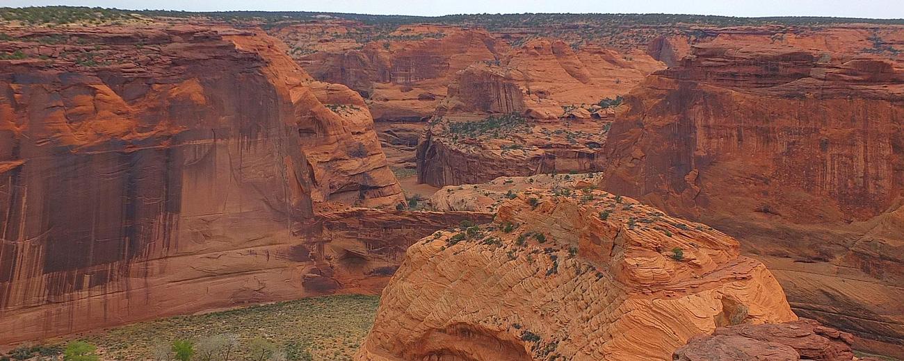


Weather information for the Canyon de Chelly National Monument area is provided below. Average temperatures, climate details and current forecasts are included!
Climate
At an elevation of 5000-6000 feet Canyon De Chelly National Monument experiences a high desert climate with extreme daily temperature changes (40 degree swing is not uncommon). In the summer, there are regularly 100+ temperatures and it is always below freezing on winter nights. Canyon De Chelly lies in the path of the summer monsoon storms, and the late summer afternoons often experience isolated thunderstorms.
Average high and low temperatures by month and average precipitation are listed below:
| Month | Avg. High |
Avg. Low |
Avg. Precip. |
| January | 43° F | 16° F | 0.7 in |
| February | 51° F | 22° F | 0.6 in |
| March | 59° F | 27° F | 0.7 in |
| April | 68° F | 34° F | 0.5 in |
| May | 77° F | 42° F | 0.5 in |
| June | 87° F | 50° F | 0.3 in |
| July | 91° F | 58° F | 1.3 in |
| August | 88° F | 57° F | 1.4 in |
| September | 82° F | 49° F | 0.9 in |
| October | 70° F | 36° F | 1.1 in |
| November | 56° F | 27° F | 0.9 in |
| December | 45° F | 17° F | 0.7 in |
Live weather is currently unavailable.
Please visit weather.gov for current and forecasted weather.
Today
Chance Rain And Snow Showers
Tonight
Chance Snow Showers
Friday
Snow Showers Likely
Friday Night
Chance Snow Showers
Saturday
Sunny
Saturday Night
Mostly Clear
Detailed Forecast |
|
|---|---|
| Today | A chance of rain and snow showers. Mostly cloudy. High near 49, with temperatures falling to around 41 in the afternoon. Southwest wind 18 to 26 mph, with gusts as high as 44 mph. Chance of precipitation is 50%. New snow accumulation of less than half an inch possible. |
| Tonight | A chance of snow showers. Mostly cloudy. Low around 21, with temperatures rising to around 23 overnight. Southwest wind 7 to 23 mph, with gusts as high as 41 mph. Chance of precipitation is 50%. New snow accumulation of 1 to 2 inches possible. |
| Friday | Snow showers likely. Mostly cloudy. High near 43, with temperatures falling to around 38 in the afternoon. West wind around 8 mph. Chance of precipitation is 60%. New snow accumulation of 2 to 4 inches possible. |
| Friday Night | A chance of snow showers before 5am. Mostly cloudy, with a low around 21. Northwest wind around 7 mph. Chance of precipitation is 40%. New snow accumulation of 1 to 3 inches possible. |
| Saturday | Sunny, with a high near 48. Northwest wind 6 to 12 mph, with gusts as high as 17 mph. |
| Saturday Night | Mostly clear, with a low around 19. Northeast wind 2 to 7 mph. |
| Sunday | Sunny, with a high near 58. South wind 1 to 6 mph. |
| Sunday Night | Mostly clear, with a low around 25. South wind around 3 mph. |
| Monday | Sunny, with a high near 62. South wind 2 to 12 mph, with gusts as high as 21 mph. |
| Monday Night | Partly cloudy, with a low around 30. South wind 7 to 10 mph, with gusts as high as 21 mph. |
| Tuesday | A chance of rain and snow showers after noon. Partly sunny, with a high near 53. Southwest wind 7 to 17 mph, with gusts as high as 31 mph. Chance of precipitation is 40%. |
| Tuesday Night | A slight chance of rain and snow showers. Mostly cloudy, with a low around 26. Southwest wind 10 to 17 mph, with gusts as high as 30 mph. Chance of precipitation is 20%. New snow accumulation of less than half an inch possible. |
| Wednesday | A slight chance of snow showers before noon, then a slight chance of rain and snow showers. Partly sunny, with a high near 52. Southwest wind 10 to 17 mph, with gusts as high as 30 mph. Chance of precipitation is 20%. |
| Wednesday Night | A slight chance of rain showers before 11pm, then a chance of rain and snow showers. Mostly cloudy, with a low around 29. Southwest wind around 16 mph, with gusts as high as 30 mph. Chance of precipitation is 30%. |