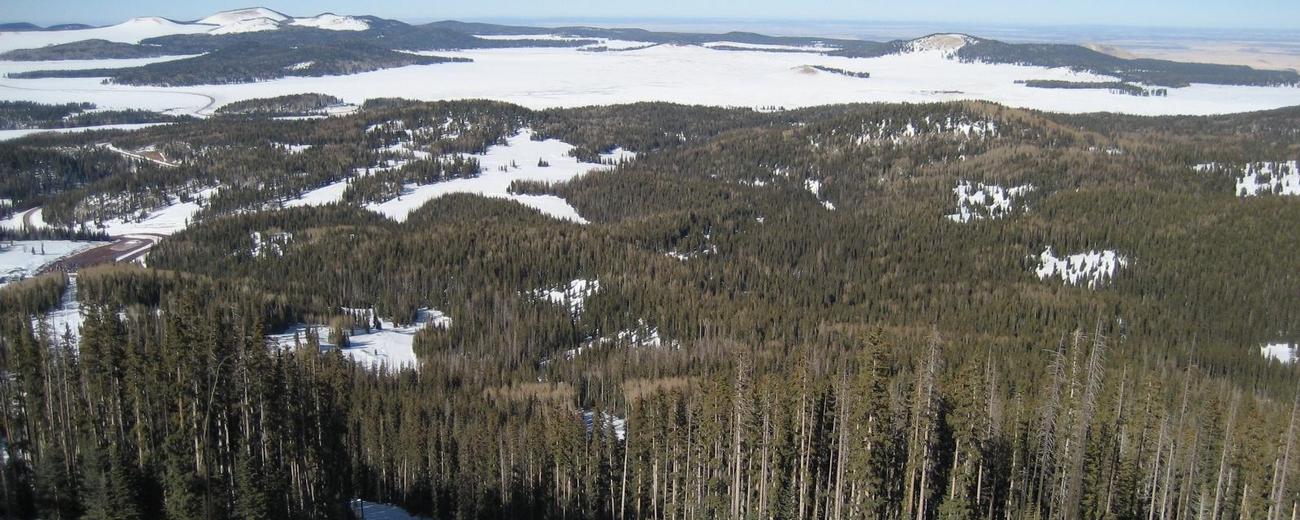
Weather information for the Sunrise Park Resort area is provided below. Average temperatures, climate details and current forecasts are included!
- Loading
Your request has been processed, thank you!
We also have the following visitor guides in Arizona. Click on any additional guides you would like to receive.


Utah - Life Elevated Statewide
Utah - Life Elevated

Prescott: An Arizona Gem Central Arizona
Prescott: An Arizona Gem

Tempe Phoenix Area - Central Arizona
Tempe

Chandler Phoenix area - Central Arizona
Chandler

Catalina Island Southern California
Catalina Island

Zion National Park - North Rim Grand Canyon Southern Utah
Zion National Park - North Rim Grand Canyon

San Juan County Southeast Utah
San Juan County

Discover Gilbert Phoenix Area
Discover Gilbert

Lake Havasu City Western Arizona
Lake Havasu City

Capitol Reef Country Central Utah
Capitol Reef Country

Town of Clifton Southeastern
Town of Clifton

Arizona - The Grand Canyon State Arizona
Arizona - The Grand Canyon State

Sierra Vista Southern Arizona
Sierra Vista

Discover Salt River Scottsdale Area
Discover Salt River

Sedona Central Arizona
Sedona

Superior Southeastern Arizona
Superior

Town of Clarkdale North-Central Arizona
Town of Clarkdale

Glendale Phoenix Area - Central Arizona
Glendale
Arizona State Parks State of Arizona
Arizona State Parks

Douglas, Arizona Southern Arizona
Douglas, Arizona
Town of Payson Central Arizona
Town of Payson

Wickenburg Central Arizona
Wickenburg

Bisbee Southern Arizona
Bisbee

Bryce Canyon Country Southern Utah
Bryce Canyon Country

Benson Southeast
Benson
Specialty Guides

Maverick Helicopters Nevada, Arizona, Hawaii, and California
Maverick Helicopters
We also have visitor guides available in states highlighted in blue below. Click on any state to see what's available.
- Alaska
- Arizona
- California
- Canada
- Colorado
- Hawaii
- Idaho
- Louisiana
- Michigan
- Montana
- Nevada
- New Mexico
- Ohio
- Oregon
- Texas
- Utah
- Washington
- Wyoming
Live weather is currently unavailable.
Please visit weather.gov for current and forecasted weather.
Overnight
Slight Chance Snow Showers
Thursday
Chance Snow Showers And Patchy Blowing Snow then Blowing Snow
Thursday Night
Areas Of Blowing Snow then Snow Showers And Areas Of Blowing Snow
Friday
Snow Showers And Patchy Blowing Snow
Friday Night
Snow Showers
Saturday
Chance Snow Showers
31°F
Wind 21 to 24 mph S
35°F
Wind 26 to 31 mph SW
21°F
Wind 20 to 28 mph SW
30°F
Wind 13 to 22 mph SW
16°F
Wind 10 to 14 mph W
30°F
Wind 9 to 14 mph NW
Detailed Forecast |
|
|---|---|
| Overnight | A slight chance of snow showers after 5am. Mostly cloudy. Low around 31, with temperatures rising to around 34 overnight. South wind 21 to 24 mph, with gusts as high as 33 mph. Chance of precipitation is 20%. New snow accumulation of less than one inch possible. |
| Thursday | A slight chance of snow showers before 8am, then a chance of snow showers and patchy blowing snow between 8am and 11am, then blowing snow and snow showers likely between 11am and 2pm, then snow showers likely and areas of blowing snow between 2pm and 4pm, then blowing snow and snow showers likely. Mostly cloudy. High near 35, with temperatures falling to around 29 in the afternoon. Southwest wind 26 to 31 mph, with gusts as high as 49 mph. Chance of precipitation is 70%. New snow accumulation of 4 to 8 inches possible. |
| Thursday Night | Areas of blowing snow and a chance of snow showers before 11pm, then snow showers and areas of blowing snow. Mostly cloudy, with a low around 21. Southwest wind 20 to 28 mph, with gusts as high as 45 mph. Chance of precipitation is 80%. New snow accumulation of 3 to 5 inches possible. |
| Friday | Snow showers and patchy blowing snow. Cloudy, with a high near 30. Southwest wind 13 to 22 mph, with gusts as high as 31 mph. Chance of precipitation is 90%. New snow accumulation of 6 to 10 inches possible. |
| Friday Night | Snow showers. Mostly cloudy, with a low around 16. West wind 10 to 14 mph, with gusts as high as 20 mph. Chance of precipitation is 80%. New snow accumulation of 3 to 7 inches possible. |
| Saturday | A chance of snow showers before 5pm. Partly sunny, with a high near 30. Northwest wind 9 to 14 mph, with gusts as high as 22 mph. Chance of precipitation is 40%. New snow accumulation of less than one inch possible. |
| Saturday Night | Mostly clear, with a low around 14. Northeast wind 3 to 8 mph, with gusts as high as 16 mph. |
| Sunday | Sunny, with a high near 44. Northeast wind around 6 mph. |
| Sunday Night | Clear, with a low around 19. Southeast wind 5 to 8 mph. |
| Monday | Sunny, with a high near 46. South wind 9 to 13 mph, with gusts as high as 28 mph. |
| Monday Night | Mostly clear, with a low around 24. Southwest wind around 14 mph, with gusts as high as 28 mph. |
| Tuesday | A chance of snow showers after 11am. Mostly sunny, with a high near 39. Southwest wind 15 to 20 mph, with gusts as high as 43 mph. Chance of precipitation is 40%. New snow accumulation of 1 to 3 inches possible. |
| Tuesday Night | A chance of snow showers before 10pm, then a chance of snow showers and patchy blowing snow. Mostly cloudy, with a low around 22. Southwest wind around 18 mph, with gusts as high as 37 mph. Chance of precipitation is 40%. New snow accumulation of 1 to 3 inches possible. |
| Wednesday | A chance of snow showers before 8am, then a chance of snow showers and patchy blowing snow. Partly sunny, with a high near 39. Southwest wind around 17 mph, with gusts as high as 36 mph. Chance of precipitation is 30%. New snow accumulation of less than half an inch possible. |